

Genealogy: Public Land Records

At the close of the American Revolution in 1783, the new United States was cash-poor and land-rich. To help fill the federal treasury and ensure an orderly settlement of lands west of the original 13 colonies, Congress devised a system of settlement to encourage westward movement. The result was the Rectangular Survey System (RSS) or Public Land Survey System (PLSS). This post is meant to give you an idea of how western lands in the U. S. were laid out for settlement and how you can find out if your ancestor bought some of this land from the federal government.
The Land Ordinance of 1785 and Northwest Ordinance of 1787 established the PLSS to control the survey, sale, and settling of the new land. Land was systematically surveyed into square townships, six miles on each side. Each township was then subdivided into 36 sections of one square mile each, or 640 acres. These sections could then be further subdivided for re-sale by settlers and land speculators.
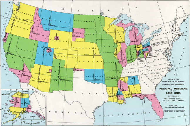
The RSS survey system is based on principal meridians and base lines determined by precise scientific measurements. When new public lands opened for sale, a north-south meridian and an east-west baseline was established to guide government surveyors in establishing townships. In the map below, each color block shows states and parts of states that were surveyed using that area’s principal meridian and base line.
After the baselines and meridians were established, surveyors and their assistants proceeded to lay out numbered townships north and south of the baseline, and to lay out numbered ranges east and west of the meridians. This process creates a grid of townships similar to a checkerboard.
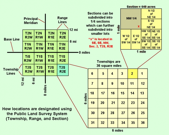
To identify a township, start counting where the principal meridian and baseline intersect. If the township “address” is T1N R2E, it means that the township is one unit north of the baseline, and two units east of the principal meridian. If this address is T2S R3W would be two units south of the baseline, and three units west of the principal meridian.
To find out if your ancestor purchased land from the federal government and obtained a patent, you can visit the Bureau of Land Management web site at http://glorecords.blm.gov. Here you can find all kinds of information relating to public land records. This site provides live access to federal land records for the public land states, including access to images of over five million federal land title records issued between 1788 and the present. It also has images of survey plats and field notes. However, it does not currently contain every federal title record issued for public land states. To get the most out of this great site, click on “Reference Center” on the homepage.
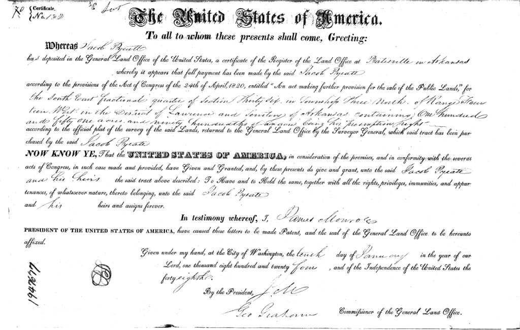
1824 land patent for Jacob Pyeatt in Arkansas
Paperwork generated in the process of public land purchase was compiled into land entry case files and is held by the National Archives and Records Administration (NARA). Early files from 1788 to the mid-1850s generally contain little genealogical information other than documentation of purchase. After passage of the 1862 Homestead Act, these files then required substantial information valuable to genealogists. No two of these files are alike, so you won’t know what’s in the file until you receive it from NARA. For more information on these files and how to obtain copies, visit https://www.archives.gov/research/land/accessing-land-entry-files.


Recent Comments