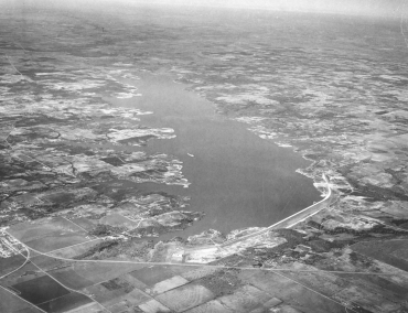
Origin and History of Lake Grapevine, 1919-1953, Part 5: A Community Prepares and Construction Begins

As seen in Part 4, construction of the Grapevine Dam and Reservoir was initially scheduled to begin by late November 1947. Before that could happen, Grapevine’s leaders clearly stated that they did not intend to let their town become “a haven for honky-tonk operators, shanty dwellers or big-city gamblers” once the project was completed. Word was already circulating around town that big-time gambling interests and nightclub operators were eager to set up shop near the lakeshore and take advantage of Grapevine’s Main Street intersecting principal Highways 121 and 114, as well as the city’s proximity to Dallas and Fort Worth. David E. Box, president of Grapevine’s First National Bank, assured the public that Dallas investors were welcome, but Grapevine wanted more of those who already had more than $5,000,000 dollars invested in estates and well-improved farm and ranches within ten miles of Grapevine. He asserted that the right kind of...

Origin and History of Lake Grapevine, 1919-1953, Part 3: The Trinity River Project Goes To Washington

In 1940, the Trinity River watershed consisted of seven regions, six of which are shown on the map below (Fig. 1): West Cross Timbers, Grand Prairie, East Cross Timbers, Blackland Prairie, Coastal Flatwood, and Coast Prairie. Grapevine lay on the border between the East Cross Timbers and Blackland Prairie regions. As mentioned in the previous blog, flooding had caused critical soil erosion and devastating crop damage to farms in the Trinity River basin. The formation of the Texas soil conservation boards in late 1939 was intended to achieve and maintain good soil conservation practices, among which was flood control. It also allowed farmers to apply for federal funds to assist them in these endeavors. Preliminary reports pertaining to the proposed Dalworth district, of which Grapevine Mayor B. R. Wall would be a supervisor, demonstrated that soil and economic conditions there were better than anticipated but still in need of attention....

Origin and History of Lake Grapevine, 1919-1953, Part 2: From The Local To The National Stage

Flood control and soil erosion had been a subject of discussion at all levels of government for many years, but it was not until the 1930s that the federal government recognized that this objective was of national importance and that it should play a leading role in providing funding to the states so they could meet those ends. The Dust Bowl storms of 1934-1935, including some in March 1935 that blew dust into Washington, DC as the hearings for a soil conservation law were being held, helped to move Congress to act. Prior to the development of the Trinity project, there was no federal or state project in the Trinity watershed pertaining to soil and water usage. Floods had devastated the region of the upper Trinity River several times during the previous thirty years. For example, when a severe flood ravaged the upper Trinity region on May 24, 1908, Grapevine...

Origin and History of Lake Grapevine, 1919-1953, Part 1: Beginnings

Lake Grapevine is a reservoir situated approximately twenty miles northwest of Dallas and northeast of Fort Worth. Located on Denton Creek, a tributary of the Elm Fork of the Trinity River, it is a popular destination for Grapevine residents and others who come to enjoy fishing, boating, camping, and other outdoor activities. Its origin and history make for a colorful tale.  The lake known today began as the Grapevine Reservoir and Dam project with the breaking of ground at Denton Creek on December 5, 1947, but its origins actually date back to October 1919 in Dallas, Texas. Spanning both Tarrant County and Denton County, it was impounded on July 3, 1952 by the US Army Corps of Engineers (ACE) in order to control flooding from the creek and to provide an additional source of water for future Dallas, University Park, and Highland Park (known as the Park Cities) population growth....

Farm Directories

Directories are much like today’s telephone books except that they offer a better panorama or “bird’s-eye view” into the makeup of a community or an organization during a particular time period. They offer an abundance of terrific clues and research tips about finding people from the past. Much of this information cannot be found elsewhere. While city directories are a popular tool for finding urban ancestors, researchers should keep in mind that there are farm directories geared toward the rural population. Like city directories, their purpose was to be a tool for businessmen. Not only do farm directories provide valuable family information—especially for those years in between the federal censuses—they also offer a kind of “snapshot” of life on the family farm. Depending on the publisher, you may find various types of information in a farm or rural directory. There were several publishers of these directories, and in today’s blog,...

The War of the Rebellion: a Compilation of the Official Records of the Union and Confederate Armies

OK, all you Civil War buffs and genealogists with Civil War ancestors; if you’re not familiar with the Official Records of Union and Confederate Armies in the War of the Rebellion, now is your opportunity to become acquainted with this important set of war documentation of events and persons involved in its military operations. The Official Records of the Union and Confederate Armies in the War of the Rebellion, commonly known as the Official Records of the Union and Confederate Armies or Official Records (OR), is the most extensive collection of American Civil War land warfare records available to the general public. It includes selected first-hand accounts, orders, reports, maps, diagrams, and correspondence drawn from official records of both Union and Confederate armies. A second publication, Supplement to the Official Records of Union and Confederate Armies, is also available, which includes specific documentation omitted from the OR as well as...

There Were 102 Passengers on the Mayflower. Was Your Ancestor One of Them?

More than thirty million people can trace their ancestry to the 102 passengers and approximately thirty crew aboard the Mayflower when it landed in Plymouth Bay on 11 November 1620. Do you have a Mayflower passenger in your past? Have you heard family stories suggesting that you have one but nobody has done the research to try to prove it? The best way to find out is to begin researching yourself and work back, documenting the generations as you go. If you’re so fortunate as to identify one or more of these pioneers as an ancestor, you may also wish to join The General Society of Mayflower Descendants, founded in 1897. You’ll also gain a deeper understanding and appreciation of the lives of these Englishmen and women who forged a new life on a new continent. The Pilgrims were a group of English people who came to America seeking religious...

Over There: World War I Genealogical Research

In Flanders Fields John McCrae – 1872-1918 In Flanders fields the poppies blowBetween the crosses, row on row,    That mark our place; and in the sky    The larks, still bravely singing, flyScarce heard amid the guns below. We are the Dead. Short days agoWe lived, felt dawn, saw sunset glow,    Loved and were loved, and now we lie        In Flanders fields. Take up our quarrel with the foe: To you from failing hands we throw    The torch; be yours to hold it high.     If ye break faith with us who dieWe shall not sleep, though poppies grow        In Flanders fields. History of US Involvement At the eleventh hour of the eleventh day of the eleventh month in 1918, a cessation of hostilities began with the signing of an armistice between Allied forces and Germany after a devastating war lasting over...

Historical County Atlases and Plat Books

Historical county atlases and plat books are bound volumes that include detailed maps of each township within a particular county. They contain maps of villages, cities, and county townships; a patron directory (those who contributed to the creation of the book); a reference business directory, illustrations, biographies, and a history of the county. They show property boundaries and land ownership for every parcel of land within a county. Besides physical features like rivers, roads, and hills, these maps showed schools, cemeteries, churches, railways, roads, and administrative boundaries. Each region had unique features; for example, some Wisconsin county atlases show locations of cheese factories. Physical features might offer reasons why residents chose to settle in a certain place. Since these books display property lines and owners as well as biographical information on some citizens, they can be extremely valuable to genealogists. County atlases and plat books contain cadastral maps. Cadastral maps...